Cycling through Stockbridge, Massachusetts, I had to stop, observe, and take some photos. I was just at the beginning of my bicycle touring sabbatical (Day 1), and I had not expected to be wowed by a thoughtful, safe, positively busy, and human-scale state street design. While stopped, I observed three Massachusetts pedestrians crossing individually at the clearly marked crosswalk with cars immediately stopping. The street design did not strand pedestrians on the side of the state route for minutes, nor did they have to play “Frogger” and risk getting stuck mid-crossing on a multi-lane highway.
Even being rather agile and physically fit, crossing multi-lane state routes in Connecticut is both frustrating and terrifying. This experience at Connecticut crosswalks is oft repeated in social media rants and community meetings.
Research on crosswalks clearly shows that lower car speeds result in drivers being much more likely to yield. The slower speeds reduce the likelihood of a collision while also making the severity of any car-pedestrian collision much less likely to cause fatality or severe injury. For example, with 37 mph traffic, the likelihood of yielding to a pedestrian at a crosswalk is only 17%. With 20 mph traffic speeds, the cars yield at 75% (source). The addition of a centerline crosswalk sign further increases the likelihood of a car driver legally and safely yielding to a pedestrian crossing the street.

I had read that Massachusetts was recently ranked as the Most Bicycle Friendly State. Stopping and observing how the recent (mid-2010s) redesign of Main Street Stockbridge was both enlightening and distressing. Many U.S. cities and towns are finally embracing a Strong Towns approach to their town centers and Main Streets.
So how come CT DOT’s approach to Main Street, town center, and business district arterials in Connecticut continues to be car-centric, economically sterile, and dangerous? Additionally, CT DOT typically skips safety and walkability improvements during state route repaving projects, considering maintenance projects too limited in scope to improve crosswalks, sidewalks, add bike lanes or change lane striping.
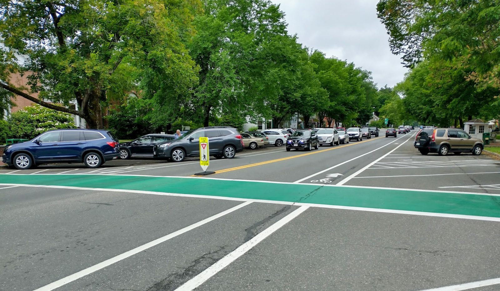
Even though Stockbridge is a small town, the town center is bustling and passes more vehicle traffic and bike/pedestrian users than you might think. Two state routes come together in Stockbridge. Regional traffic and local traffic combines right there in the busy center.
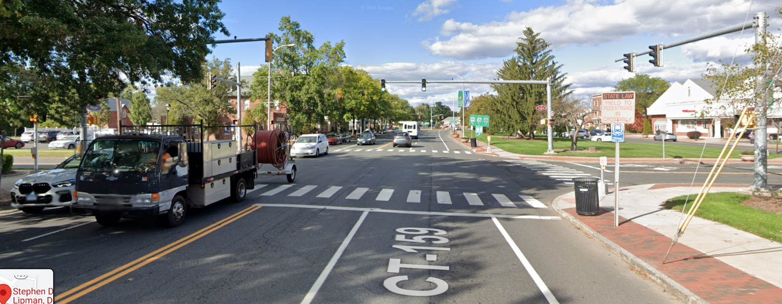
There is a natural slowing of that traffic speed due to the single lane design through the town center. The 20 mph speed limit is clearly marked along with parking, bike lanes, and bright green crosswalks. The speed is human scale and feels much calmer and safer than a car-centric, extra wide Connecticut state route through many of our cities and town centers. People walk and bike safely to and through the Stockbridge town center – crossing the street without undue stress – able to go safely on foot from one to another local shopping destination or appointment. It looked and felt idyllic.
The width of the corridor in Stockbridge was more committed to greenspace and tree canopy than asphalt traffic lanes and extra wide intersections with dedicated turning lanes. That said, the overall corridor width was similar to other Connecticut town centers. Stockbridge and Mass DOT could have chosen to pave their town center with a wider motor vehicle focus, more lanes, and longer crosswalks. They intentionally chose to instead focus on an enjoyable, shady, traffic-calmed town center – where one is invited to stop, linger, shop, have a coffee, and perhaps look for an apartment.
The Connecticut Department of Transportation is recently saying it is interested in safer, more economically vital town centers and urban areas. With the legislatively mandated creation of the Vision Zero Council and a stronger focus on active transportation and transit, one can hope that their design and planning approach for state routes in these important communities soon reflects the needs of the residents, the adjacent businesses, and our planet.
Unfortunately we’re still seeing CT DOT repaving projects in urban areas and town centers entirely leave out simple lane restriping, traffic calming, and crosswalk improvements. The repaving of Connecticut Boulevard (State Route 44) in East Hartford between Main Street, the riverfront trails, and Downtown Hartford didn’t incorporate crosswalks, kept the same wide multi-lane design, and left out bike lanes. Just saying that active transportation, safety, and economic development are important doesn’t get it done. Fingers crossed that future projects go beyond rhetoric and incorporate proven safer and more human-friendly designs.
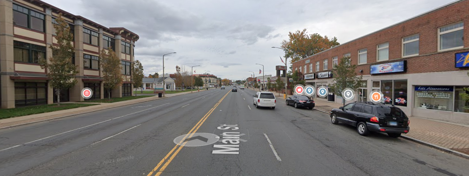
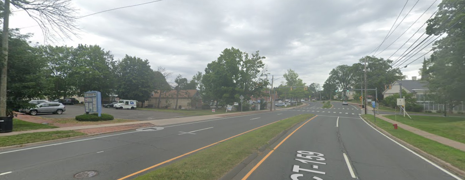
East Hartford, CT Windsor, CT Stockbridge, MA Town center arterial road name and state route designation Main Street, State Routes 5 & 44 Broad Street, State Route 159 Main Street, State Routes 7 & 102 Parallel interstate serving same direction of through traffic travel Yes, I-91 to State Route 2 (no tolls) Yes, I-91 (no tolls) Yes, I-90, Massachusetts Turnpike (tolls) Population of Town 51,045 (2020) 29,492 (2020) 2,018 (2020) Median Household Income $59,954 (2020) $92,079 (2020) $48,571 Average Daily Traffic (ADT) 20,600 (2018) 8,600 (2019) 16,800 (2018) Posted speed limit 30 mph, speed limit signs not clearly posted 30 to 35 mph, clearly posted 20 mph, clearly posted with feedback signs Number of through travel lanes 4 (2 each direction), some sections with 6 lanes (3 each direction) 4 (2 each direction), additional parallel parking lane in southbound direction that is sometimes empty
For a short length in the town center there is a parallel local road, adding 2 more lanes on the other side of the town green2 (1 each direction) Dedicated turn lanes Yes, dedicated left and right turn lanes at several signalized intersections in Downtown area Most of the length doesn’t have dedicated turn lanes, expect for the large intersection with State routes 305 & 75 No dedicated left or right turn lanes Truck traffic allowed Yes Yes Yes Street Parking Parallel parking allowed in very wide curb lane, but not delineated with street marking Parallel parking lane in the outside of extra wide southbound lane in town center area, parking is not delineated with street marking Angle-in parking both sides, heavily utilized
No parking areas near intersections and crosswalks clearly marked with paintBicycle lanes No No Yes, paint marked bike lanes in both directions between travel lane and angle-in parking Bus or rail transit Yes, relatively frequent CTtransit bus service on Main Street Yes, CTtransit stops and nearby Hartford Line commuter rail station Yes, hourly BRTA bus service Crosswalk treatment and design Zebra crosswalks at signalized intersections with pedestrian signals, all stop button activated crosswalks, very long crossing distances Zebra crosswalks at non-signalized and signalized intersections. Several blinking signs were recently added at non-signalized intersections, but not very effective. Bright green crosswalks with centerline crosswalk signs, crosswalks at intersections and mid-block crossing locations, short crossing distances, no parking zones marked for crosswalk visibility Pedestrian traffic crossing distance` 75.4 feet (up to 6 lanes of traffic, no central refuge island) 58.0 to 74.5 feet (four traffic lanes + parallel parking lane when empty) 22 feet (2 traffic lanes) Curb to curb width of pavement 75.4 feet (including outer parallel parking lane) 58.0 feet (including shoulder and parallel parking lane) 67.8 feet (including nose-in angled parking) Width of corridor from edge of sidewalk to edge of sidewalk 106.7 feet (sidewalk goes right up to building frontage) 82.1 feet, but there is much more with considering the adjacent town green and local business access road 102.5 feet (some additional distance to buildings)